Top 5 Benefits CAD Drawing Services Deliver to Surveyors

Land surveying has undergone a massive transformation over the last few decades. The days of relying solely on optical theodolites, chains, and hand-drafted mylar sheets are long gone. While the fundamental principles of measuring the earth remain the same, the tools used to process and present that data have evolved rapidly.
At the center of this technological shift sits Computer-Aided Design (CAD). For modern surveyors, the challenge isn't just collecting accurate data in the field; it is translating that complex data into clear, usable plans for architects, engineers, and developers. This is where professional CAD drawing services come into play.
By moving away from manual drafting and embracing digital solutions, surveying firms can streamline their workflows and deliver higher-quality results. Whether done in-house or through partners like Archdraw outsourcing, leveraging CAD technology is no longer optional—it is essential for staying competitive. Here is how CAD services are reshaping the surveying industry.
Unmatched Accuracy and Precision
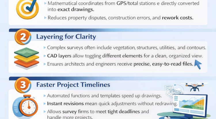
The primary responsibility of a land surveyor is accuracy. A discrepancy of even a few inches can lead to expensive property disputes, construction errors, and legal headaches down the road. Traditional manual drafting, while an art form, always carried the risk of human error. A slight slip of the ruler or a misinterpretation of field notes could compromise the integrity of a survey.
CAD software eliminates these manual inconsistencies. Because the software processes mathematical coordinates directly from the surveyor’s data collectors (total stations or GPS units), the resulting drawings are mathematically perfect.
Layering for Clarity
Beyond just placing lines correctly, CAD allows for sophisticated layering. In a complex topographical survey, a surveyor needs to show vegetation, structures, utility lines, and elevation contours simultaneously.
With CAD, each of these elements is assigned to a specific layer. This means users can toggle different layers on and off to view specific data without visual clutter. This level of precision ensures that architects and engineers receive clean, organized files where every measurement is exact and every feature is clearly defined.
Accelerating Project Timelines
In the construction and real estate industries, time is almost always the most constrained resource. Developers need site plans immediately to secure permits, and architects cannot begin their designs until the survey is complete. Manual drafting is inherently slow and labor-intensive, often creating a bottleneck in the project pipeline.
CAD drawing services significantly reduce the time required to go from fieldwork to finished deliverables. Automated functions and standard templates speed up the creation of routine elements like legends, title blocks, and standard symbols.
Furthermore, revisions are instantaneous. If a client requests a change in scale or needs additional data points added later, the drafter does not need to redraw the entire plan. They simply modify the existing digital file. This agility allows survey firms to handle tighter deadlines and accept more projects without compromising quality.
Cost-Effectiveness and Resource Management
Running a surveying firm involves significant overhead. Between maintaining expensive field equipment, vehicle fleets, and insurance, profit margins can be tight. Hiring a full team of senior CAD technicians to handle drafting in-house adds another layer of fixed costs, including salaries, benefits, and software licensing fees.
This is where the strategic advantage of outsourcing comes into play. By utilizing services like Archdraw outsourcing, surveying firms can convert fixed costs into variable costs. You only pay for the drafting work you need when you need it.
Reducing Waste and Rework
CAD also saves money by reducing errors that lead to rework. In the past, a mistake on a physical draft might mean scrapping the entire sheet and starting over. Digital files can be corrected in minutes. Additionally, the ability to share digital files electronically eliminates printing and shipping costs during the draft review stages.
Seamless Data Integration
Surveying data rarely lives in a vacuum. It is usually the foundation for a much larger project involving civil engineering, urban planning, or architectural design. One of the most significant benefits of CAD is its ability to integrate with other advanced technologies.
Modern surveying often involves Light Detection and Ranging (LiDAR), photogrammetry, and drone data. These methods produce millions of data points, known as "point clouds." Manual drafting methods simply cannot handle this volume of information.
CAD software can import these massive datasets and convert them into usable 3D models and 2D plans. Furthermore, CAD files are easily compatible with Building Information Modeling (BIM) software and Geographic Information Systems (GIS). This interoperability allows the surveyor’s work to plug directly into the architect’s workflow, fostering better collaboration and reducing data translation errors between disciplines.
Improved Visualization for Clients
Not every client is a technical expert. While another surveyor or a civil engineer might easily interpret a 2D contour map, a property developer or a homeowner might struggle to visualize the terrain based on lines on a page.
CAD services bridge this communication gap through advanced visualization. Beyond standard 2D site plans, CAD enables the creation of:
- 3D Wireframes: Showing the skeletal structure of the terrain.
- Digital Terrain Models (DTM): Offering a solid surface view of the land's topography.
- Rendered Walkthroughs: Allowing clients to virtually "stand" on the property.
By providing clear, 3D visualizations, surveyors can help clients make better decisions faster. It turns abstract data into a tangible reality, which adds significant value to the service provided.
The Future of Surveying is Digital
The transition from analog to digital processes has revolutionized how surveyors work. By adopting CAD drawing services, firms can deliver results that are more accurate, timely, and visually compelling than ever before.
Whether it is through internal software adoption or by partnering with specialized providers like Archdraw outsourcing, the goal remains the same: to provide the highest quality data to build the world around us. As technology continues to advance, the integration of CAD in surveying will only become deeper, making it an indispensable tool for any firm looking to grow.
What's Your Reaction?